

Cropping Patterns in Different Agro-Climatic Zones of India – UPSC Agriculture Optional
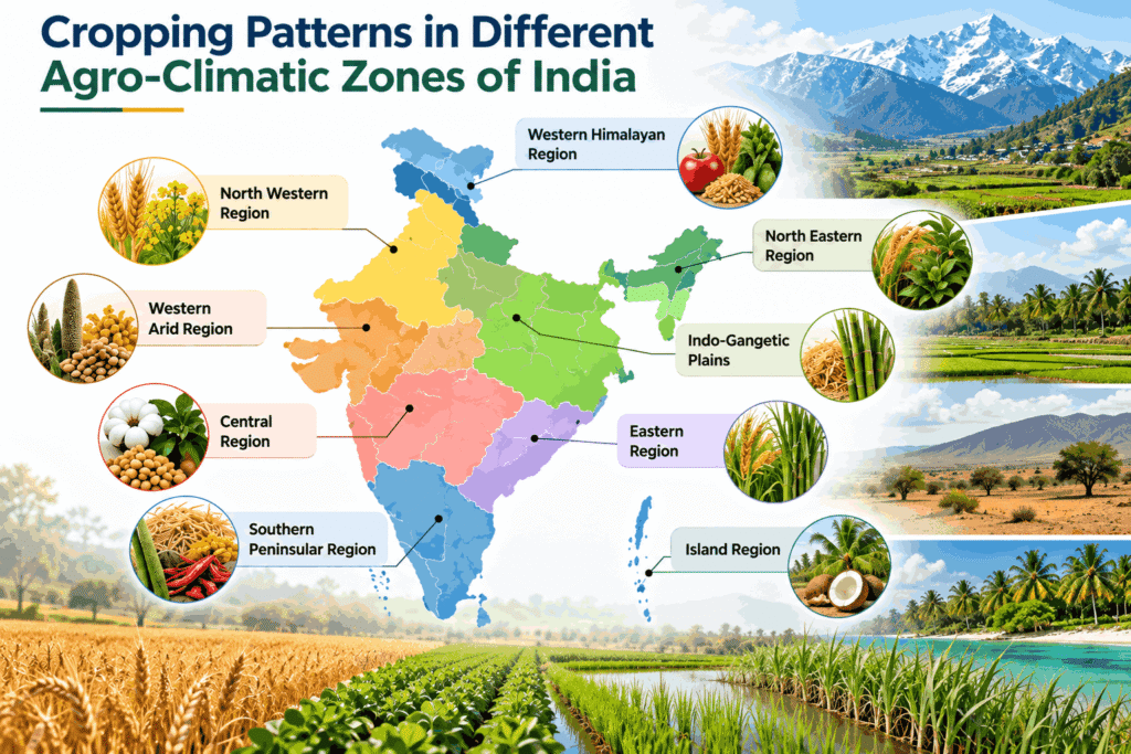
The study of cropping patterns across diverse agro-climatic zones (ACZs) forms the bedrock of sustainable land-use planning and agricultural resource management. For the UPSC Agriculture Optional examination, mastering the spatial distribution of crops, the scientific classification of ecological zones, and the shifting dynamics of cropping patterns is critical for writing high-scoring answers.
1. Conceptual Framework: Cropping Pattern vs. Cropping System
Understanding the precise scientific distinction between a cropping pattern and a cropping system is essential for maintaining accuracy in answer writing.
- Cropping Pattern: Refers to the proportion of land area allocated to various crops at any given point in time, as well as their spatial arrangement and temporal (yearly) sequence on a specific piece of land. It is a dynamic reflection of how farmers utilize soil, water, and climate resources across different agricultural seasons (Kharif, Rabi, and Zaid) to maximize yield and minimize socio-economic risks.
- Cropping System: A broader, holistic concept. It encompasses the cropping pattern used on a farm plus its interaction with available farm resources (soil, water, labor, capital), farm technologies, and management practices. Mathematically, it can be understood as:
Cropping System = Cropping Pattern + Management Practices
2. Understanding Agro-Climatic and Agro-Ecological Classifications
Agro-Climatic Zone (ACZ)
As defined by the Food and Agriculture Organization (FAO), an Agro-Climatic Zone is a land unit defined precisely in terms of its major climate, rainfall profile, temperature regimes, and Length of Growing Period (LGP), which is climatically suitable for a certain range of crops and cultivars.
UPSC Exam Tip (Terminology): Length of Growing Period (LGP) refers to the continuous period of the year (expressed in number of days) when available soil moisture and thermal conditions are suitable for crop growth. It occurs when precipitation (P) exceeds half of the potential evapotranspiration (PET) i.e., P > 0.5 PET.
Frameworks of Ecological Classification in India
India uses three primary institutional classifications to design location-specific agricultural interventions:
|
Classification Authority |
Number of Zones |
Core Delineation Criteria |
Primary Objective |
|---|---|---|---|
|
Planning Commission of India (7th Five-Year Plan, 1988) |
15 Zones |
Rainfall, temperature, soil types, topography, and water resources. |
Regional balanced development, micro-level agricultural planning, and reducing regional disparities. |
|
National Agricultural Research Project (NARP) by ICAR |
127 Zones |
Rainfall pattern, temperature, soil characteristics, cropping patterns, and administrative boundaries. |
Establishing Zonal Research Stations (ZRS) for location-specific, need-based agro-technologies. |
|
National Bureau of Soil Survey & Land Use Planning (NBSS&LUP) |
20 Agro-Ecological Regions (AERs) (Further split into 60 sub-regions) |
Physiography, soil type, bio-climate, and Length of Growing Period (LGP). |
Macromapping of land eco-systems for sustainable land-use planning and biophysical optimization. |
Criteria for Delineating Agro-Climatic Zones – UPSC Agriculture Optional
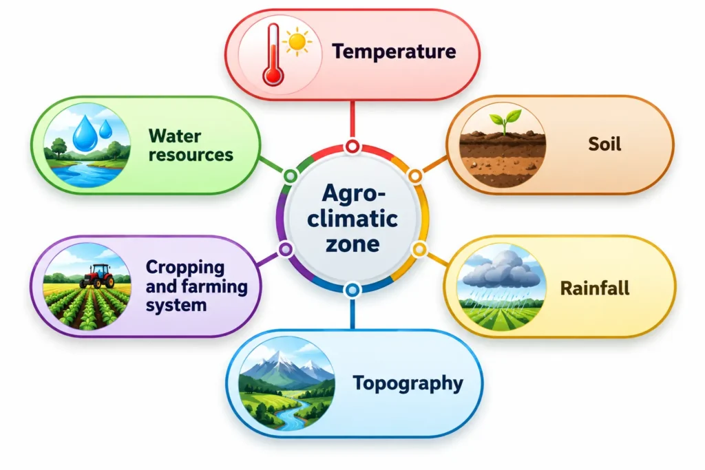
The delineation of an Agro-Climatic Zone (ACZ) is not based on a single ecological parameter, but rather on an integrated matrix of six core biophysical and socio-agricultural criteria: temperature, rainfall, soil, topography, water resources, and existing cropping/farming systems. These factors collectively determine the Length of Growing Period (LGP) and dictate the ecological boundaries within which specific crop cultivars can be sustainably cultivated.
1. Rainfall (Precipitation Profile)
Rainfall is the most crucial variable for determining moisture availability in dryland and rainfed farming ecosystems.
- Parameters Evaluated: Total annual quantum, seasonal distribution (South-West vs. North-East monsoon), onset and withdrawal dates, and dry-spell frequencies.
- Role in Zoning: It segregates hyper-arid zones (e.g., Western Dry Region, < 30 cm) from humid zone ecosystems (e.g., Eastern Himalayan Region, > 250 cm), directly controlling choice between drought-hardy millets or water-intensive paddy.
2. Temperature Regimes
Temperature sets the thermodynamic limits for physiological processes like photosynthesis, transpiration, and vernalization.
- Parameters Evaluated: Mean monthly maximum and minimum temperatures, diurnal temperature variations, and occurrence of extreme events like frost or heatwaves.
- Role in Zoning: It distinguishes temperate alpine conditions of the Western Himalayas (suitable for saffron and temperate horticulture) from tropical/sub-tropical conditions of the Indo-Gangetic plains.
3. Soil Characteristics (Edaphic Matrix)
Soil acts as the physical reservoir for water and essential plant nutrients, defining the chemical baseline of an ACZ.
- Parameters Evaluated: Soil texture (clay, loam, sand), depth, water-holding capacity, pH, and inherent nutrient status.
- Role in Zoning: Heavy, moisture-retentive Vertisols (Black Soils) in the Western Plateau require completely different moisture-management and cropping sequences compared to the highly leached, acidic Laterite soils of the West Coast.
4. Topography and Physiography
The physical relief layout of the land alters microclimates, drainage patterns, and soil erosion dynamics.
- Parameters Evaluated: Altitude/elevation, slope gradient, aspect (sun-facing vs. shade slopes), and terrain ruggedness.
- Role in Zoning: Steep slopes in hilly zones necessitate terrace cultivation, agro-forestry, and contour farming to check topsoil erosion, while vast plain landforms permit highly mechanized, intensive multi-cropping setups.
5. Water Resources (Hydrological Assets)
Irrigation potential changes a zone’s baseline vulnerability by decoupling crop growth from erratic rainfall patterns.
- Parameters Evaluated: Surface water infrastructure (canal networks), groundwater draft-to-recharge ratios, water table depth, and water quality (salinity/alkalinity hazards).
- Role in Zoning: The availability of canal and tube-well networks transforms an otherwise semi-arid geographic area like the Trans-Gangetic plain into a highly secure, intensive perennial food bowl.
6. Existing Cropping and Farming Systems
This represents the socio-economic and historical adaptation of the farming community to the underlying biophysical resources.
- Parameters Evaluated: Dominant crop rotations, crop combinations, multi-tier setups, and integration with allied sectors (livestock, fisheries, apiculture).
- Role in Zoning: Delineation factors in whether a region is historically structured around a subsistence monoculture (e.g., Jhumming in the Northeast) or advanced commercial plantation matrices (e.g., West Coast multi-tier systems).
3. Comprehensive Analysis: 15 Agro-Climatic Zones & Their Cropping Patterns
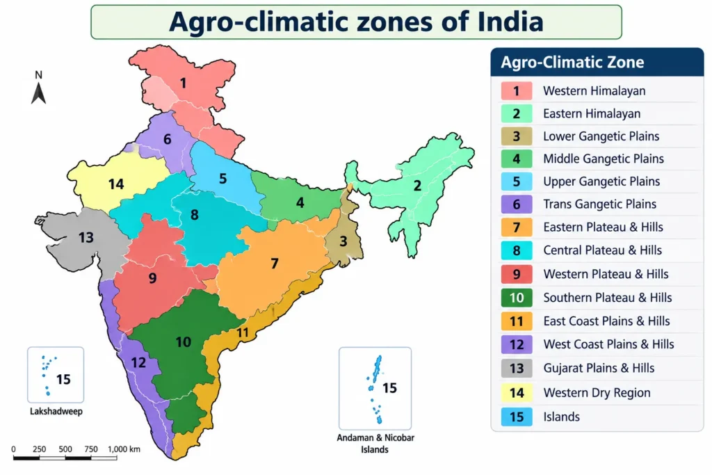
Below is the detailed breakdown of the 15 Agro-Climatic Zones delineated by the erstwhile Planning Commission, highlighting their geographic spread, ecological constraints, and dominant cropping patterns.
Zone 1: The Western Himalayan Region – UPSC Agriculture Optional
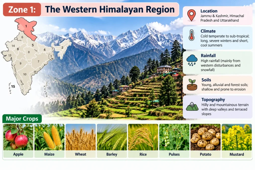
The Western Himalayan Region represents a distinct, ecologically fragile geographic unit characterized by extreme vertical zonation, micro-climatic variations, and a high reliance on temperate high-value agriculture. In the UPSC Agriculture Optional syllabus, this zone serves as a classic study of hill agriculture, watershed management, and climate-adaptive cropping patterns.
1. Biophysical and Ecological Profile
Geographic Spread
The region encompasses the entire northern mountainous stretch of India, including the Union Territories of Jammu & Kashmir and Ladakh, the state of Himachal Pradesh, and the Kumaon-Garhwal divisions of Uttarakhand.
Climatic Regimes & Rainfall
- Temperature Profile: Governed entirely by altitude. Summers are exceptionally mild, with average July temperatures ranging between 5°C and 30°C. Winters are characterized by severe alpine cold, with January temperatures plunging to 0°C to -4°C (and significantly lower in the trans-Himalayan rain shadow zones).
- Rainfall Profile: The average annual rainfall varies between 75 cm and 150 cm, driven by South-West monsoons and Winter Western Disturbances. However, the trans-Himalayan district of Ladakh acts as a cold desert, receiving less than 30 cm of annual precipitation.
Edaphic Matrix (Soils) & Vegetation
- Soil Characteristics: The predominant texture is silty loam. Valley floors and flat structural depressions (duns like the Kashmir Valley, Kullu Valley, and Dehradun) feature thick, fertile layers of alluvium. Conversely, the steep hill slopes are dominated by immature, shallow, and highly erodible thin brown hilly soils.
- Natural Vegetation: Exhibits sharp altitudinal zonation, transitioning from sub-tropical scrub at the foothills to temperate coniferous forests (Deodar, Pine), and finally to alpine pastures at high elevations.
2. Water Resources and Infrastructure
The region functions as the “water tower” of North India. It is drained by major perennial river systems, including the Ganga, Yamuna, Jhelum, Chenab, Satluj, and Beas.
- Agricultural Impact: While these rivers provide abundant gravity-fed canal irrigation to valley floors, steep terrains rely heavily on traditional diversion channels known as Kuhls.
- Industrial Linkage: The steep hydraulic gradients provide abundant, cheap hydroelectric power, which drives rural agro-processing industries, cold storages, and lift-irrigation schemes.
3. Cropping Patterns and Farming Systems
The distribution of agronomic activities is strictly aligned with the land’s slope gradient and altitudinal thermal thresholds.
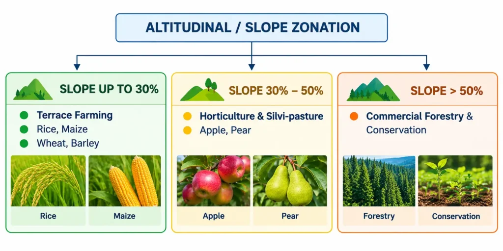
Agronomic Matrix by Topography
- Valley Floors: Characterized by intensive cereal rotations. Rice is the dominant monocrop during Kharif, while Wheat and Barley dominate the Rabi window.
- Terrace Agriculture (Up to 30% Slope): Farmers practice subsistence and semi-commercial cultivation of Maize, Wheat, Potato, and Barley on meticulously carved contour terraces.
- Horticulture and Silvi-Pastoral Systems (30% to 50% Slope): This belt is optimized for high-value temperate fruits like Apple, Peach, Pear, Walnut, Plum, and Apricot. Environmental conditions also favor niche commodities:
- Saffron Cultivation: Restricted to the unique Karewa soils of Jammu & Kashmir (Pampore).
- Specialty Crops: High-value cash crops such as Ginger, temperate off-season vegetables, floriculture, and hill tea plantations (e.g., Palampur in Himachal Pradesh).
- Forestry Zones (Above 50% Slope): Strictly preserved under natural siliculture to maintain ecological balance and mitigate downslope mass wasting.
Pastoral Economy
At high altitudes, the ecosystem transitions into alpine meadows locally known as Dhoks or Margs (e.g., Gulmarg, Sonamarg). These pastures support a vibrant pastoral economy run by nomadic and semi-nomadic tribes like the Gujjars, Bakarwals, and Gaddis, who practice transhumance to rear sheep, goats, and hill cattle for wool, meat, and dairy.
4. Ecological Bottlenecks and Structural Problems
Despite its high economic potential, agriculture in the Western Himalayan Region is constrained by severe biophysical and infrastructural vulnerabilities:
- Fragile Physiographic: The young, tectonically active terrain is highly prone to accelerated soil erosion, landslides, and cloudbursts, which frequently destroy terrace infrastructure.
- Infrastructural Deficits: Due to rugged topography, the region suffers from poor rural accessibility. The lack of temperature-controlled cold chains, processing units, and reliable storage facilities leads to high post-harvest losses in perishable horticultural crops.
- Climate Vulnerability: Winter farming is frequently disrupted by inclement weather and prolonged frost. Rising temperatures due to climate change are shifting apple cultivation belts to higher altitudes.
- Socio-Economic Stagnation: The farming demographic is highly fragmented, predominantly rural, smallholder-based, and economically marginalized.
Zone 2: The Eastern Himalayan Region – UPSC Agriculture Optional
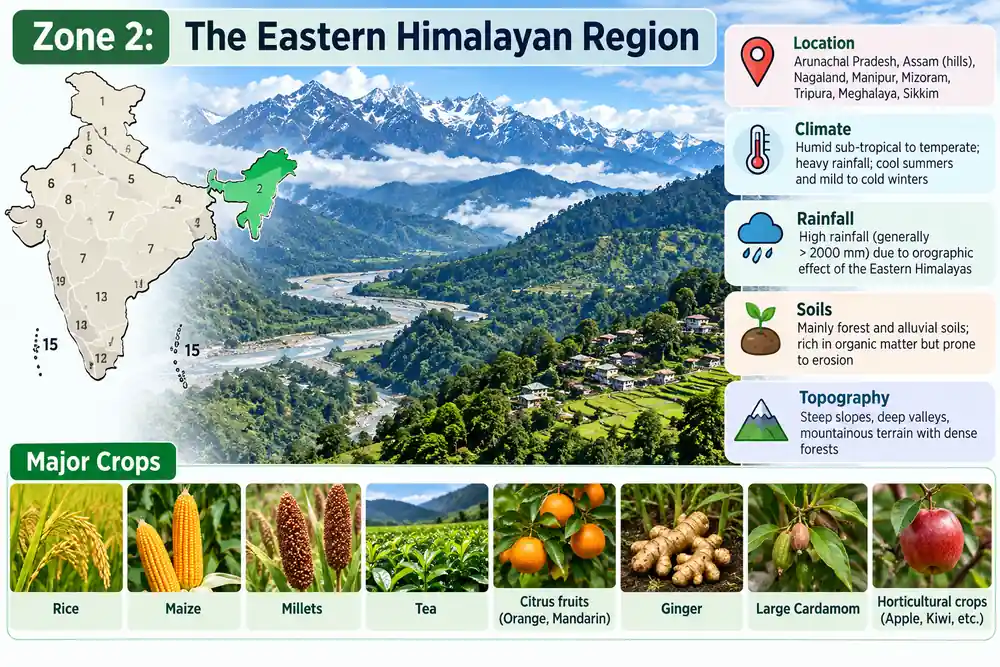
1. Biophysical and Ecological Profile
- Geographic Spread: Sikkim, Darjeeling hills (West Bengal), Arunachal Pradesh, Assam hills, Nagaland, Meghalaya, Manipur, Mizoram, and Tripura.
- Climate & Rainfall: Warm, humid to sub-humid climate. Summer temperature (July) ranges from 25°C to 33°C; winter temperature (January) ranges from 10°C to 24°C. It is the wettest zone in India, receiving an average annual rainfall of 200 cm to 400 cm.
- Edaphic Matrix (Soils): Dominated by thick-layered, brownish forest soils. Due to torrential rains, these soils suffer from intense nutrient leaching, making them highly acidic (low pH) and deficient in available phosphorus.
2. Cropping Patterns and Farming Systems
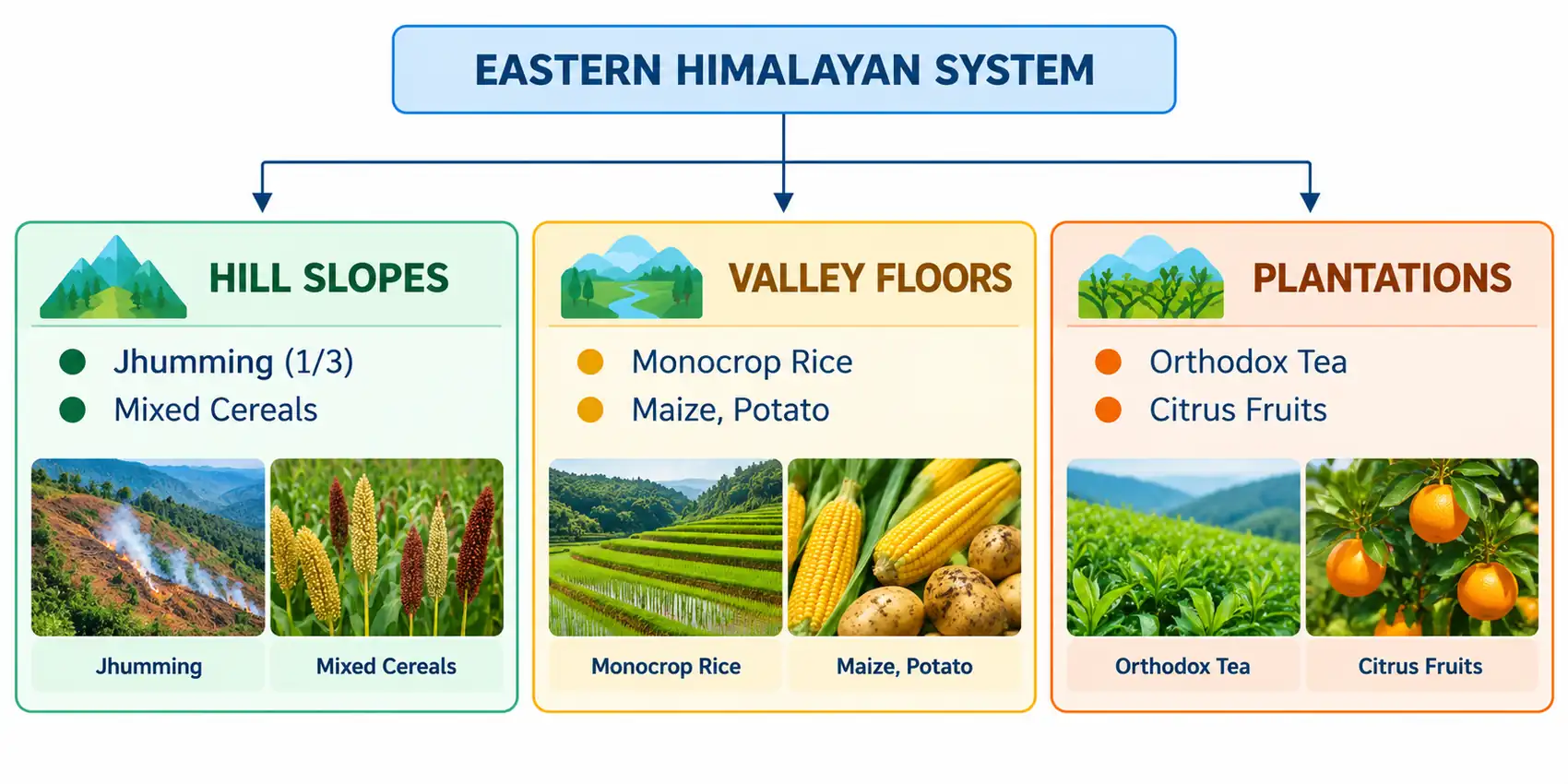
- Shifting Cultivation (Jhum): Practiced across nearly one-third (1/3) of the cultivated area. Slopes are cleared by slashing and burning vegetation to raise mixed food crops (Rice, Maize, Millets) primarily for subsistence.
- Settled Field Crops: Rice is the undisputed staple crop in plains and valley floors. Maize, Potato, and Pulses are major secondary crops.
- Horticulture & Plantations: The region is a hub for premium orthodox tea (Darjeeling/Assam hills), large cardamom (Sikkim), ginger, and tropical/sub-tropical fruits like Mandarin orange, pineapple, and litchi.
3. Core Problems & Sustainable Way Forward
Structural Problems
- Accelerated Soil Degradation: Deforestation and unscientific Jhumming on steep slopes cause catastrophic topsoil erosion.
- Shortened Jhum Cycles: Population pressure has shrunk fallow periods from 20 years down to 2–3 years, preventing soil nutrient regeneration.
- Infrastructural Deficits: Rugged terrain causes poor transport accessibility, a lack of cold chains, and inadequate storage facilities.
Strategic Solutions
- Jhum Control: Phase out shifting cultivation by encouraging permanent settlement through Bench Terracing (slopes < 30%) and SALT (Sloping Agricultural Land Technology).
- Acid Soil Amelioration: Apply Lime (CaCO3) or dolomite to neutralize soil acidity and unlock fixed phosphorus for crop uptake.
- Organic Farming Matrix: Expand Sikkim’s successful 100% organic farming framework across the Northeast to capture premium export markets for niche spices and floriculture.
Zone 3: The Lower Gangetic Plains Region – UPSC Agriculture Optional
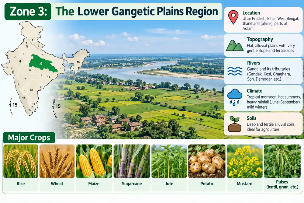
1. Biophysical and Ecological Profile
- Geographic Spread: Eastern Bihar, West Bengal, and the Assam Valley.
- Climate & Rainfall: Typically hot and humid. Summer temperature (July) varies from 26°C to 41°C; winter temperature (January) ranges from 9°C to 24°C. The region receives a high average annual rainfall of 100 cm to 200 cm.
- Edaphic Matrix (Soils): Dominated by deep, highly fertile alluvial soils with a fine clay to silty-clay texture. These soils exhibit high moisture-retention capacity but are prone to structural compaction.
2. Water Resources and Hydrological Constraints
- Hydrological Assets: The region possesses abundant groundwater reserves coupled with a perennially high water table. Wells and canals constitute the primary infrastructure for irrigation.
- Ecological Constraints: Due to low-lying topography and heavy precipitation, the problems of waterlogging and marshy lands (e.g., Beels and Tal lands) are acute, leading to poor soil aeration during the monsoons.
3. Cropping Patterns and Farming Systems
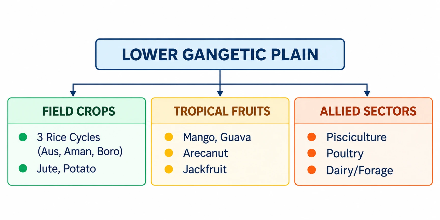
- Triple Rice Cropping Matrix: Rice is the absolute staple. The high water table and thermal windows allow farmers to harvest up to three successive rice crops in a single year on the same piece of land:
- Aus: Autumn rice (sown in May–June, harvested in Sept–Oct).
- Aman: Winter rice/Agahani (sown in June–July, harvested in Nov–Dec; accounts for the largest acreage).
- Boro: Summer rice (sown in Nov–Dec, harvested in May–June; highly productive under assured irrigation).
- Commercial Cash Crops: Jute is the premier commercial cash crop, rotating perfectly with rice due to overlapping moisture regimes. Maize, Potato, and Pulses are key secondary crops.
- Horticultural Base: Abundant backyard and commercial cultivation of tropical fruits including Mango, Guava, Arecanut, and Jackfruit.
4. Core Problems & Sustainable Way Forward
Structural Problems
- Severe Land Fragmentation: Extreme small size of landholdings limits economies of scale and restricts mechanical modernization.
- Socio-Economic Stagnation: Deep-rooted poverty among smallholders prevents high-capital input investments.
- Drainage Congestion: Inadequate drainage networks turn high water tables into productivity-limiting waterlogging liabilities.
Strategic Solutions
- Promotion of Allied Activities: Accelerate income diversification by integrating high-density horticulture (Banana, Mango, Citrus), pisciculture (freshwater aquaculture in wetlands), poultry, and livestock with synchronized forage production.
- Post-Harvest and Export Infrastructure: Establish a dedicated Export Processing Zone (EPZ) for marine and seafood equipped with modern freezing, canning, dehydration, and stringent quality control facilities to capture domestic and global value chains.
- Input and Seed Security: Strengthen institutional decentralized seed supply chains to provide flood-tolerant and short-duration crop cultivars.
Zone 4: The Middle Gangetic Plains Region – UPSC Agriculture Optional
1. Biophysical and Ecological Profile
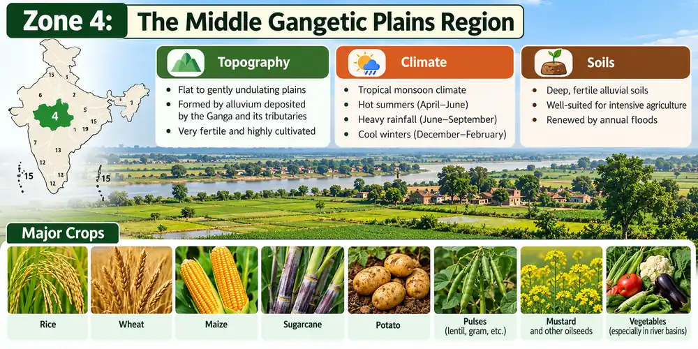
- Geographic Spread: Eastern Uttar Pradesh and Bihar (excluding the Chhotanagpur Plateau).
- Climate & Rainfall: Hot, humid summers and mild winters. Summer temperature (July) ranges from 26°C to 41°C; winter temperature (January) ranges from 9°C to 24°C. The annual rainfall is between 100 cm and 200 cm.
- Edaphic Matrix (Soils): Highly fertile alluvial plains deposited by the Ganga River and its major perennial tributaries (Ghaghra, Gandak, Kosi).
2. Hydrological Profile & System Intensity
- Water Resources: Vast potential of both groundwater aquifers and surface runoff. Irrigation is extensively carried out through tube wells, canals, and open wells.
- Key Agricultural Metrics: Around 30% of the Gross Cropped Area (GCA) is under assured irrigation. The region operates at a Cropping Intensity of 142%.
3. Cropping Patterns and Farming Systems
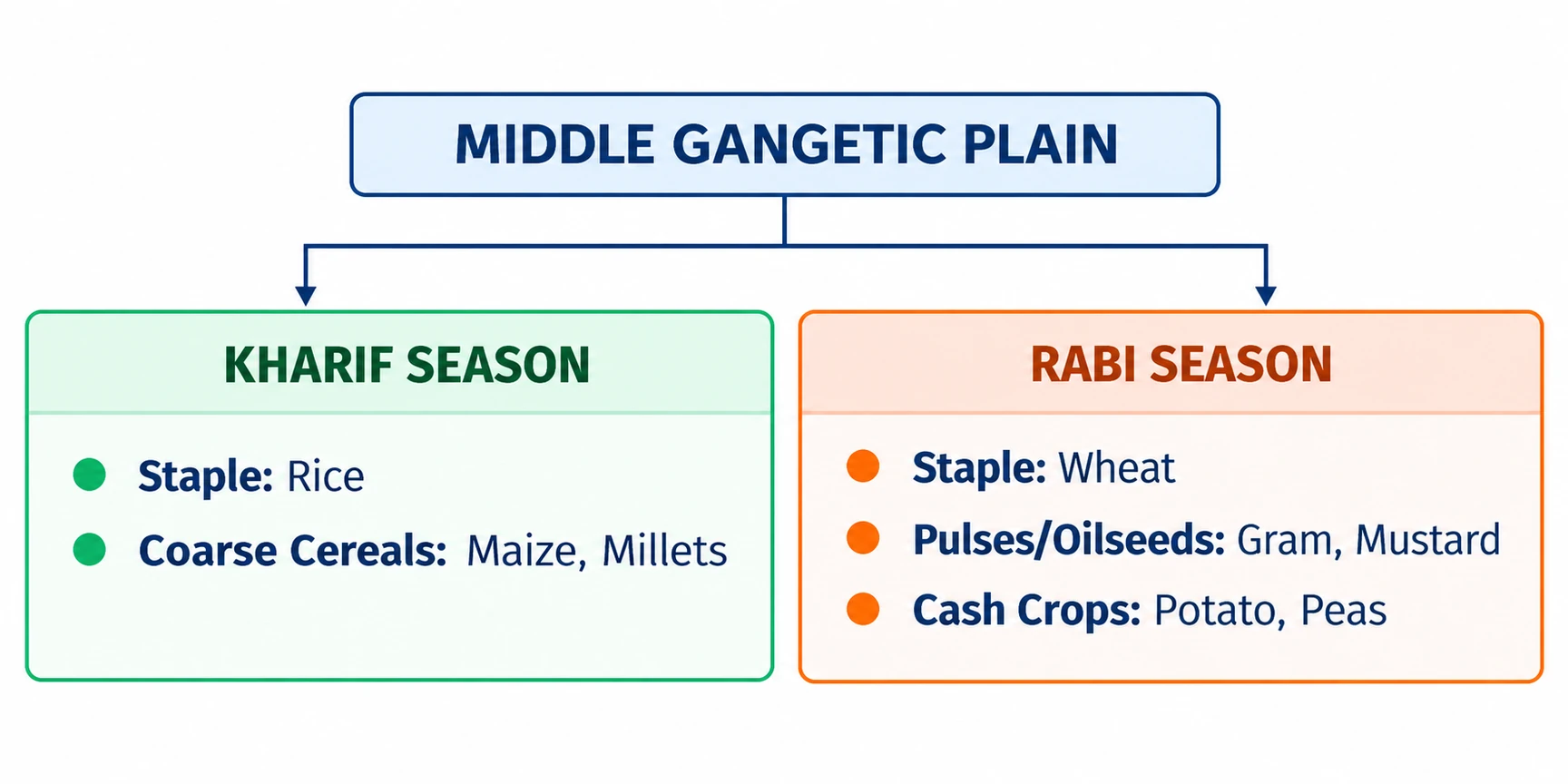
- Kharif Cropping Matrix: Dominated by water-sufficient crop combinations. Rice is the primary staple, supplemented by Maize and Millets on relatively upland patches.
- Rabi Cropping Matrix: Diversified cereal-cash crop rotations. Wheat is the primary driver, integrated with pulses (Gram, Peas), oilseeds (Mustard), Barley, and commercial Potato cultivation.
4. Core Problems & Strategic Solutions
Structural & Biophysical Problems
- Micronutrient Disorders: Widespread Zinc (Zn) deficiency in soils, leading to severe visual disorders and yield drops in rice crops.
- Edaphic Degradation: Accelerated soil erosion along riverbanks, accompanied by alkaline and saline formations (Usar soils) in poorly drained pockets.
- Topographic Waterlogging: Large structural depressions remain submerged for months, rendering them uncultivable during the monsoon.
- Socio-Economic Barriers: Extreme small size of landholdings and deep-rooted farmer poverty limit technical input adoption.
Strategic Solutions
- Wetland Optimization: Convert low-lying, waterlogged Chaur lands into productive pisciculture (aquaculture) zones to generate parallel rural income streams.
- Edaphic Reclamation: Reclaim degraded Usar (alkaline) lands, wastelands, and seasonal fallows through gypsum application and alternative land-use systems like agro-forestry, silviculture, and commercial floriculture.
- Integrated Nutrient Management (INM): Address soil deficiencies by promoting widespread basal application of Zinc Sulfate (ZnSO4) in paddy fields.
Zone 5: The Upper Gangetic Plains Region – UPSC Agriculture Optional
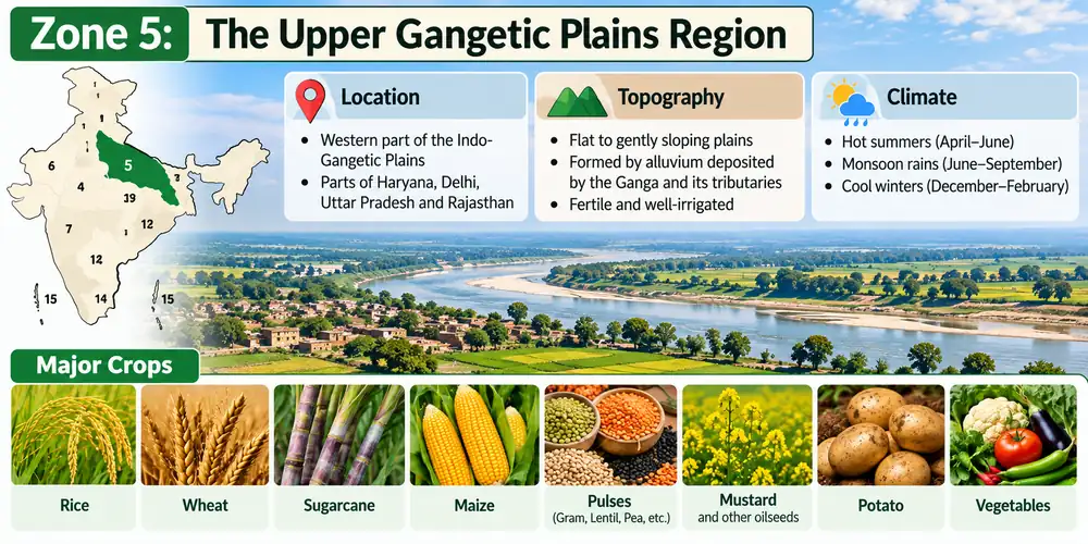
The Upper Gangetic Plains Region is a highly productive, sub-humid agricultural belt characterized by extensive canal and tubewell irrigation network density, commercial cash-cropping, and growing eco-degradation risks. In the UPSC Agriculture Optional syllabus, it stands as a key zone for studying sugarcane-based cropping systems, irrigation-induced salinity, and agricultural market volatility.
1. Biophysical and Ecological Profile
- Geographic Spread: Encompasses the central and western parts of Uttar Pradesh and the plain terrain parts of Uttarakhand.
- Climate & Rainfall: Sub-humid climate profile. Summer temperature (July) ranges from 26°C to 41°C; winter temperature (January) drops to between 7°C and 23°C. The average annual rainfall ranges from 75 cm to 150 cm (showing a progressive decrease compared to the Eastern zones).
- Edaphic Matrix (Soils): Transitionary alluvial variants, ranging from well-drained sandy loamy (uplands/Bangar) to heavy clayey loamy textures (lowlands/Khadar).
2. Water Resources & Hydro-Agricultural Footprint
- Irrigation Sources: Exceptionally high irrigation intensity driven by an intensive network of canals, tube-wells, and traditional wells.
- Water Management Impact: Assured water availability has converted this zone into a commercial cash-crop hub, though it has triggered structural soil and groundwater imbalances.
3. Cropping Patterns and Farming Systems
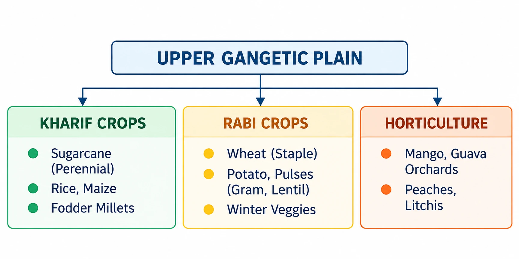
- Kharif Cropping Matrix: Sugarcane acts as the primary perennial cash driver. Other seasonal crops include Rice, Maize, Pulses, and Millets grown predominantly as green fodder.
- Rabi Cropping Matrix: Highly mechanized cultivation led by Wheat. This is tightly rotated with commercial Potato, oilseeds, winter vegetables, and pulse combinations (Gram, Lentil).
- Horticultural Abundance: Globally and nationally renowned for commercial fruit orchards, producing high-value Mango (e.g., Malihabadi Dussehari), Guava, Peaches, and Litchis.
4. Core Problems & Strategic Solutions
Structural & Biophysical Problems
- Irrigation-Induced Edaphic Degradation: Flood irrigation in water-guzzling crops (Sugarcane, Paddy, Wheat) has caused capillary rise of salts, forming extensive saline and alkaline soils (Usar or Reh lands).
- Market and Price Volatility: High fluctuations in sugarcane prices coupled with payment delays (cane arrears) create deep economic stress for farmers.
- Post-Harvest Deficits: Inadequacy of modern cold chains, processing infrastructure, and regulated storage facilities for perishable horticultural crops.
Strategic Solutions
- Leguminous Crop Substitution: Replace highly soil-exhaustive cereal-cash crops with leguminous crops (Pigeonpea, Chickpea, Moong) to break pest cycles, improve soil structure, and fix atmospheric nitrogen.
- Lowland Optimization: Upgrade low-lying basins using localized water harvesting structures and sustainable alternative farming frameworks.
- Integrated Aquaculture: Utilize waterlogged lowlands and rural depressions for productive pisciculture to create non-crop income avenues.
Zone 6: The Trans-Gangetic Plains Region – UPSC Agriculture Optional
1. Biophysical and Ecological Profile
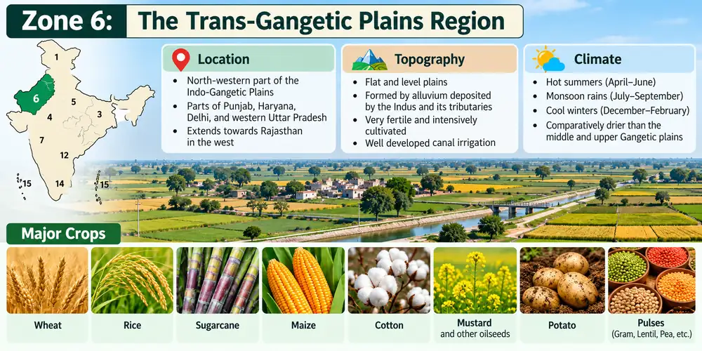
- Geographic Spread: Encompasses Punjab, Haryana, Delhi, Chandigarh, and the Ganganagar district of Rajasthan.
- Climate & Rainfall: Typically semi-arid. Summer temperature (July) ranges between 26°C and 42°C; winter temperature (January) ranges from 7°C to 22°C. The average annual rainfall is low to moderate, lying between 70 cm and 125 cm.
- Edaphic Matrix (Soils): Highly productive, deep alluvial soils (indus-alluvium). Textures vary from sandy loams to clay loams, generally deficient in organic carbon but responsive to chemical inputs.
2. Water Resources and Hydrological Crisis
- Irrigation Infrastructure: Driven by an extensive network of canals and a high concentration of private tube wells, giving the region the highest irrigation intensity in India.
- The Hydrological Paradox:
- Groundwater Depletion: Unregulated extraction has caused a sharply falling water table in fresh groundwater zones.
- Waterlogging: Poor drainage in canal command areas has raised the water table close to the surface, creating permanent wetlands and salinity hazards.
3. Cropping Patterns and Farming Systems
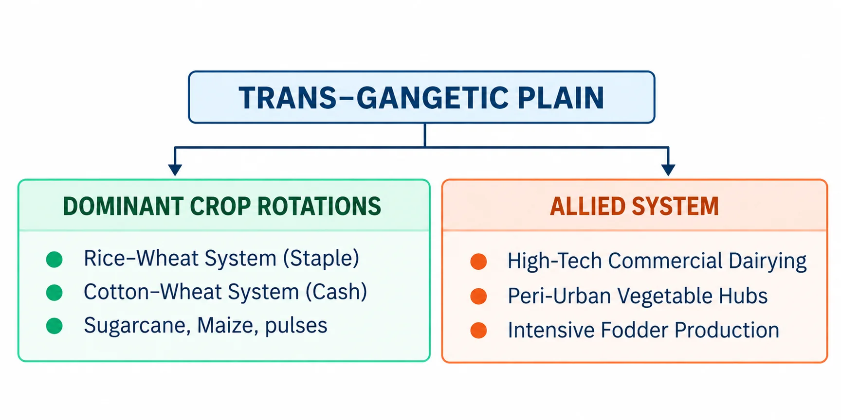
- The Rice–Wheat System: The dominant cereal–cereal monoculture. Rice serves as the major water-guzzling Kharif driver, followed by highly mechanized Wheat in the Rabi window.
- Cash Crop Rotations: Cotton–Wheat rotations dominate the relatively lighter soil belts of south-western Punjab and Haryana. Perennial Sugarcane, Maize, Millets, Pulses (Gram), and oilseeds are secondary components.
- Allied Dairy Matrix: Dairying is a primary economic driver integrated into the farming system. The region is renowned for high-yielding indigenous breeds (e.g., Murrah buffaloes) sustained by intensive green fodder cultivation.
4. Core Problems & Strategic Solutions
Structural & Biophysical Problems
- Ecological Exhaustion: The continuous Rice–Wheat rotation is highly soil-mining, leading to macro and micronutrient deficiencies.
- Edaphic Degradation: High evaporation combined with canal seepage causes extensive salinity and alkalinity (Kallar or Thur soils). Soil erosion is also prominent in seasonal riverbeds and foothills.
- Groundwater Overdraft: Free electricity policy encourages excessive pumping, threatening long-term agricultural sustainability.
Strategic Solutions
- Crop Diversification Matrix: Break the Rice–Wheat cycle by introducing less water-intensive leguminous pulses like Tur (Arhar) and Peas under upland conditions.
- Horticulture & Fodder Expansion: Expand the acreage under high-yielding commercial fruits (e.g., Kinnow citrus) and specialized high-quality fodder crops to sustain the livestock sector.
- Peri-Urban Vegetable Farming: Promote intensive vegetable cultivation clusters in the direct vicinity of industrial zones and urban centers (e.g., NCR region) to capture high-value fresh markets.
Zone 7: The Eastern Plateau and Hills Region – UPSC Agriculture Optional
The Eastern Plateau and Hills Region is an environmentally challenging, rainfed agronomic zone characterized by an undulating plateau topography, acidic soil profiles, and scarce water resources. In the UPSC Agriculture Optional syllabus, it represents a primary study area for dryland agriculture, rainfed rice systems, and soil acidity management.
1. Biophysical and Ecological Profile
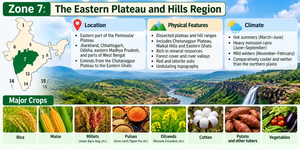
- Geographic Spread: Encompasses the Chotanagpur Plateau (Jharkhand), Rajmahal Hills, Chhattisgarh Plains, and the Dandakaranya Plateau (Odisha/Chhattisgarh).
- Climate & Rainfall: Sub-humid tropical climate. Summer temperature (July) ranges from 26°C to 34°C; winter temperature (January) varies between 10°C and 27°C. The region receives an average annual rainfall of 80 cm to 150 cm, which is highly seasonal and erratic.
- Edaphic Matrix (Soils): Dominated by weathered red and yellow soils, with occasional patches of laterites on higher hills and alluvium in narrow valley pockets. Due to heavy seasonal leaching, most soils are strongly acidic, low in water-holding capacity, and deficient in available phosphorus.
2. Water Resources and Hydrological Constraints
- Hydrological Deficits: The hard-rock plateau structure limits groundwater recharge, resulting in a scarce and deep underground water table.
- Irrigation Bottlenecks: Streams are almost entirely non-perennial (seasonal), drying up during rabi. The rugged, undulating topography poses severe physical obstacles to establishing conventional canal or tube-well irrigation networks.
3. Cropping Patterns and Farming Systems
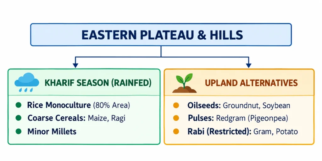
- Rainfed Kharif Dominance: Agriculture is predominantly rainfed and subsistence-oriented. During the Kharif season, Rice monoculture occupies nearly 80% of the cultivated area.
- Subsistence Crop Matrix: Rice is supplemented by coarse cereals and millets such as Maize, Ragi (Finger Millet), and minor millets.
- Rabi Cropping: Extremely restricted due to lack of residual soil moisture. Where limited irrigation exists, winter crops like Gram and Potato are raised.
4. Core Problems & Strategic Solutions
Structural & Biophysical Problems
- Nutrient Depletion: Intense leaching on sloped terrains strips the topsoil of basic cations, leading to severe macro and micronutrient deficiencies.
- Socio-Economic Stagnation: Agriculturally one of the most backward regions in India. Farmers are predominantly tradition-bound smallholders, and chronic rural unemployment triggers seasonal distress migration.
- Topographic Disadvantages: Severe runoff velocities on un-bunded slopes accelerate rill and gully erosion, destroying the thin soil cover.
Strategic Solutions
- Edaphic Amelioration: Mandatory application of Lime (CaCO3) or basic slag to neutralize soil acidity, fix toxic aluminum, and unlock essential phosphorus.
- Upland Crop Diversification: Shift vulnerable upland slopes away from moisture-sensitive paddy toward drought-hardy legumes and oilseeds. Key crops to encourage include Groundnut, Soybean, and Redgram (Pigeonpea).
- Mechanical & Biological Soil Conservation: Implement intensive contour bunding, bench terracing, and vegetative barriers (e.g., Vetiver grass) to break runoff velocity and conserve topsoil.
- Seed Security: Introduce high-quality, short-duration, drought-tolerant seed varieties to adapt to erratic monsoon onset and terminal drought events.
Zone 8: The Central Plateau and Hills Region – UPSC Agriculture Optional
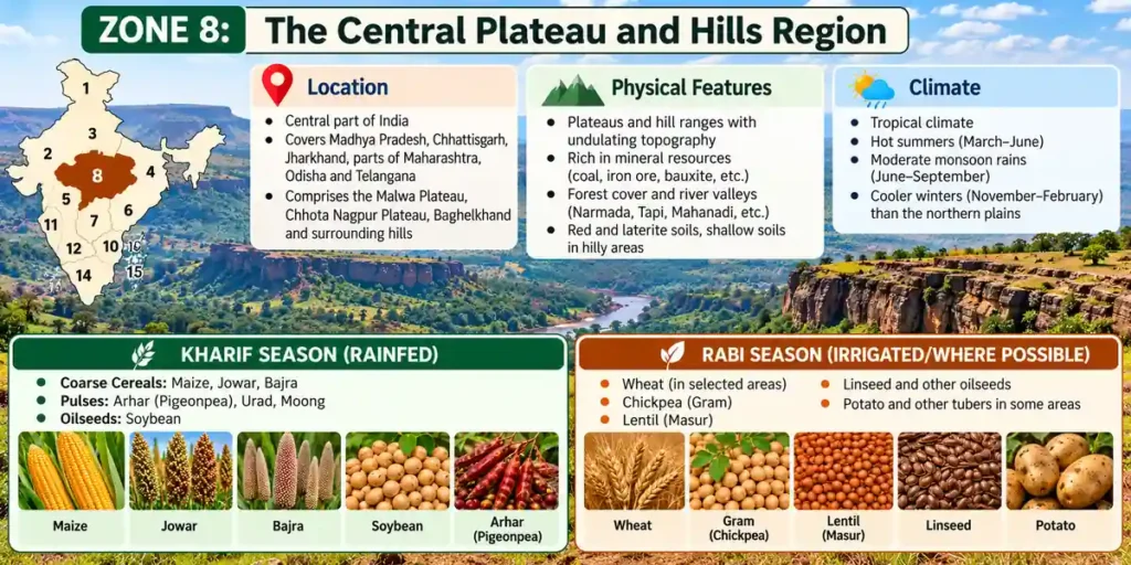
The Central Plateau and Hills Region is a transitional, risk-prone agricultural zone characterized by highly variable edaphic conditions, a severe dearth of water resources, and an overwhelming dependence on monsoon rainfall. In the UPSC Agriculture Optional syllabus, it stands as a core case study for dryland farming, watershed interventions in hard-rock terrains, and pulse-oilseed-based cropping systems.
1. Biophysical and Ecological Profile
- Geographic Spread: Spreads across the historical and physiographic regions of Bundelkhand, Baghelkhand, Bhander Plateau, Malwa Plateau, and the Vindhyachal Hills. It encompasses major parts of Madhya Pradesh, southern Uttar Pradesh, and eastern Rajasthan.
- Climate & Rainfall: Exhibits a distinct transition from a semi-arid climate in the western part (Malwa/Rajasthan borders) to a sub-humid climate in the eastern part (Baghelkhand). Summer temperature (July) ranges from 26°C to 40°C; winter temperature (January) varies between 7°C and 24°C. The average annual rainfall is low and erratic, varying from 50 cm to 100 cm.
- Edaphic Matrix (Soils): Highly heterogeneous soil profile consisting of mixed red, yellow, and black soils. The red soils predominate on upland ridges (low water retention), while deep black vertisols occupy valley basins (high moisture retention but prone to cracking).
2. Hydrological Profile and Constraints
- Hydrological Scarcity: The region suffers from a severe dearth of water resources. Streams are predominantly seasonal and flash-flood-prone.
- Groundwater Limitations: The underlying geology is dominated by ancient hard-rock formations (granite and gneiss blocks), rendering the underground water table scanty. Groundwater extraction is technically difficult, energy-intensive, and highly constrained. Consequently, agriculture remains heavily dependent on the vagaries of the monsoon.
3. Cropping Patterns and Farming Systems
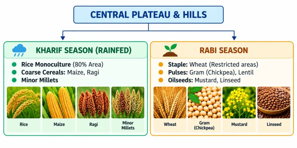
- Kharif Cropping Matrix: Dominated by low-water-requiring commercial crops and coarse grains. Soybean (particularly in the Malwa belt) and Cotton are the primary cash drivers, alongside Maize, Millets, and Kharif pulses (Pigeonpea/Mung).
- Rabi Cropping Matrix: Reliant almost entirely on residual soil moisture or supplementary deficit irrigation. Wheat is grown where water permits. However, the region excels in Rabi pulses (Gram and Lentil) and oilseeds (Mustard), which adapt well to terminal moisture stress.
4. Core Problems & Strategic Solutions
Structural & Biophysical Problems
- Low Agricultural Remunerativeness: Due to high climate risks and low yields, it remains a less developed, subsistence-dominated farming zone.
- Hard-Rock Aquifer Exhaustion: Open-dug wells dry up rapidly in early winter, leading to widespread crop failures during the critical Rabi reproductive phase.
- Severe Edaphic Erosion: Bundelkhand and the Chambal-Vindhyan fringes suffer from severe gully erosion and ravine formation, rendering vast swathes of land uncultivable.
Strategic Solutions
- Mandatory Dry Farming Practices: Institutionalize advanced dryland technologies, including mulching (to check evaporation), antitranspirant sprays, and the adoption of deep-rooted, drought-hardy crop cultivars.
- Comprehensive Package Programmes: Implement government-backed integrated package plans providing synchronized access to climate-resilient seeds, customized micro-insurance, and localized agro-processing hubs to make farming economically viable.
- In-Situ Moisture Conservation: Scale up water harvesting through the restoration of traditional tank systems (e.g., Bundelkhand’s Chandela/Bundela tanks), field bunding, and the construction of check dams to recharge hard-rock fractures.
Zone 9: The Western Plateau and Hills Region – UPSC Agriculture Optional
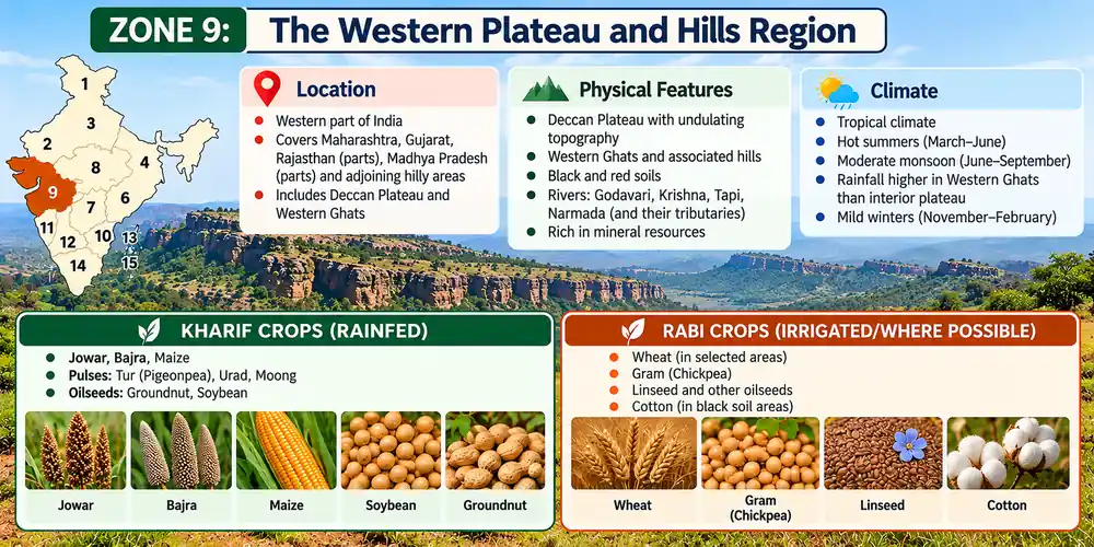
The Western Plateau and Hills Region is a major semi-arid agronomic zone dominated by the basaltic Deccan trap topography. It stands as a prominent region for studying dryland farming, micro-irrigation management, and commercial dryland horticulture.
1. Biophysical and Ecological Profile
- Geographic Spread: Encompasses the southern part of the Malwa Plateau and the major part of the Deccan Plateau, covering almost the entirety of Maharashtra.
- Climate & Rainfall: Characterized by a semi-arid to dry sub-humid climate. The mean monthly temperature remains consistently warm, tracking above 20°C. The average annual rainfall is low and erratic, ranging between 25 cm and 75 cm.
- Edaphic Matrix (Soils): Dominated by highly fertile, deep-to-shallow Black Cotton Soils (Vertisols). These soils are rich in clay, possess an exceptionally high water-holding capacity, but are prone to severe cracking during dry spells and poor drainage during intense downpours.
2. Hydrological Profile and Constraints
- The Rain-Shadow Effect: The region lies directly within the rain shadow region of the Western Ghats, which blocks the moisture-laden South-West monsoon winds.
- Irrigation Deprivation: The zone is severely deficient in water resources. Historically, only 12.4% of the net sown area is irrigated, leaving nearly 88% of farming dependent on erratic seasonal rainfall.
3. Cropping Patterns and Farming Systems
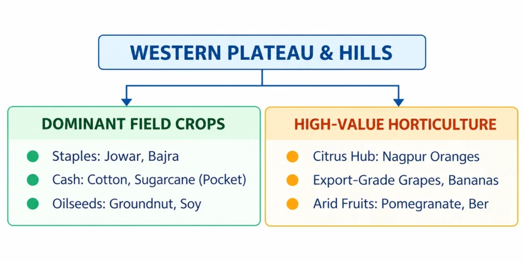
- Agronomic Matrix: Principal field crops include Jowar (Sorghum), Bajra (Pearl Millet), Cotton, Groundnut, pulses, and oilseeds. In pockets with localized canal or groundwater access, water-intensive crops like Sugarcane, Rice, and Wheat are cultivated.
- Commercial Horticulture Hub: Despite aridity, this region is a leading national producer of high-value fruits:
- Oranges: Globally renowned citrus clusters around Nagpur.
- Grapes & Bananas: High-tech commercial viticulture (e.g., Nashik) and intensive banana plantations (e.g., Jalgaon).
4. Core Problems & Strategic Realignment
Structural & Biophysical Problems
- Severe Water Scarcity: Groundwater aquifers in the basaltic terrain have poor storage capacity, leading to rapid water table depletion.
- Unscientific Crop Choice: Cultivating water-guzzling Sugarcane in water-stressed pockets (e.g., Marathwada) triggers severe socio-ecological and hydrological crises.
- Low-Value Crop Stagnation: Traditional reliance on low-value rainfed coarse grains yields poor economic returns for smallholders.
Strategic Solutions
- Expansion of Micro-Irrigation: Popularize high-efficiency water-saving devices like drip and sprinkler systems to dramatically increase Water Use Efficiency (WUE) in cash crops.
- High-Value Crop Substitution: Shift away from low-value rainfed wheat and millets toward drought-resilient, high-value oilseeds like Sunflower, Safflower, and Mustard.
- Dryland Horticulture Integration: Diversify farm income by substituting at least 5% of the area under rainfed cotton and jowar with drought-hardy, high-value arid fruits like Ber, Pomegranate (Anar), Mango, and Guava.
Zone 10: The Southern Plateau and Hills Region – UPSC Agriculture Optional
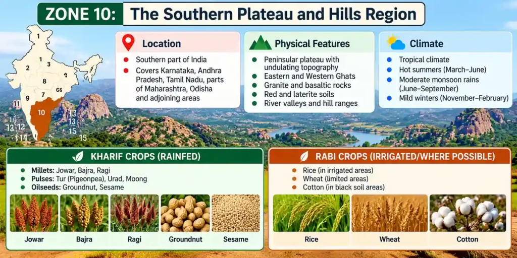
The Southern Plateau and Hills Region is a major semi-arid agronomic zone located within the core peninsular shield of India. It is characterized by a high dependency on rainfed dryland farming, low cropping intensity, and a sharp distinction between plateau field crops and high-value slope plantation systems. In the UPSC Agriculture Optional syllabus, it serves as a primary case study for dryland crop diversification, watershed rehabilitation, and integrated livestock-horticulture systems.
1. Biophysical and Ecological Profile
- Geographic Spread: Encompasses southern Maharashtra, interior Karnataka (Mysore and Bangalore plateaus), western Andhra Pradesh (Rayalaseema region), and northern Tamil Nadu.
- Climate & Rainfall: Typically semi-arid. Summer temperature (July) ranges from 26°C to 42°C; winter temperature (January) remains mild, varying between 10°C and 21°C. The region receives a low to moderate average annual rainfall of 50 cm to 100 cm, which is highly erratic and poorly distributed.
- Edaphic Matrix (Soils): Dominated by weathered red sandy soils (Alfisols) with low water-holding capacity, low organic matter content, and a tendency to form surface crusts. Pockets of shallow black soils (Vertic variants) are found in structural depressions.
2. Hydrological Profile & System Intensity
- The Dryland Reality: A striking 81% of the total cultivated area is under dryland farming, leaving the region highly vulnerable to frequent meteorological and agronomy droughts.
- Agricultural Intensity Metrics: Only about 50% of the total geographical area is actively cultivated. Due to severe seasonal moisture limitations, the region operates at a low Cropping Intensity of 111%.
- Systemic Vulnerability: Inadequate irrigation infrastructure (heavily reliant on seasonal tanks and over-exploited tube-wells) makes the regional agricultural economy highly unsustainable and highly sensitive to monsoon failure.
3. Cropping Patterns and Farming Systems
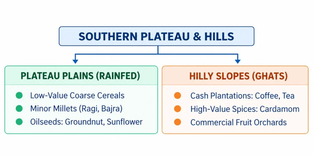
- Plateau Plain Matrix: Historically dominated by low-value coarse cereals and minor millets (e.g., Ragi in Karnataka, Sorghum/Jowar, and Pearl Millet/Bajra) grown under subsistence rainfed conditions.
- Hill Slope Matrix: The transitional hill slopes of the Karnataka plateau and Western Ghat borders support highly profitable commercial plantation crops including Coffee, Tea, Cardamom, and assorted high-value spices.
- Oilseed Pockets: Groundnut and Sunflower constitute major cash-generating rainfed field crop systems in this matrix.
4. Core Problems & Strategic Realignment
Structural & Biophysical Problems
- Low Cropping Efficiency: The 111% cropping intensity reflects an almost total inability to raise a second crop during the Rabi window due to complete profile moisture exhaustion.
- Edaphic Surface Crusting: Red soils (Alfisols) tend to form a hard surface crust immediately after rainfall, which restricts rainwater infiltration and severely impairs seed emergence.
- High Drought Vulnerability: Lack of perennially assured surface water canals leaves smallholders completely exposed to multi-season climate shocks.
Strategic Solutions
- Crop Diversification & Substitution: Divert land area away from low-value rainfed coarse cereals toward high-value, drought-resilient pulses (Pigeonpea, Chickpea) and oilseeds (Sunflower, Groundnut, Castor) to improve farm income and soil fertility.
- Integrated Farming Systems (IFS): Aggressively promote and subsidize dairy development, poultry farming, and sheep/goat rearing to provide a resilient, non-crop income buffer for dryland smallholders.
- Dryland Horticulture: Encourage the cultivation of low-water-requiring fruit systems (e.g., Pomegranate, Custard Apple, Aonla) on marginal lands.
Zone 11: The East Coast Plains and Hills Region – UPSC Agriculture Optional
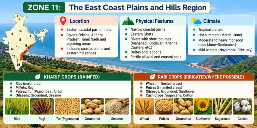
The East Coast Plains and Hills Region is a highly productive, coastal maritime zone characterized by intensive alluvial cultivation, deltaic geography, and high vulnerability to marine hazards. In the UPSC Agriculture Optional syllabus, it represents a crucial region for studying coastal salinity management, rice fallow exploitation, and plantation-aquaculture matrices.
1. Biophysical and Ecological Profile
- Geographic Spread: Encompasses the extensive coastal strip of eastern India, primarily incorporating the Coromandel Coast and the Northern Circar Coast across Andhra Pradesh, Odisha, and parts of coastal Tamil Nadu.
- Climate & Rainfall: Features a sub-humid maritime climate with moderated thermal variations. Average temperatures range from 26°C to 32°C in May (summer peak) and 20°C to 29°C in January (mild winter). The average annual rainfall ranges between 75 cm and 150 cm, received via both the South-West monsoon and late-season North-East monsoonal cyclonic systems.
- Edaphic Matrix (Soils): Dominated by deep, highly fertile deltaic and coastal alluvium with texture gradients varying from medium loams to heavy, water-retentive clays.
2. Agricultural Productivity & National Contribution
The region serves as a core food bowl for India, contributing significantly to the national grain and oilseed repository:
- Rice Share: Accounts for 20.33% of the total national rice production, thriving in the canal-irrigated delta systems of the Mahanadi, Godavari, and Krishna rivers.
- Groundnut Share: Accounts for 17.05% of the country’s groundnut production, cultivated extensively in coastal sandy-loam tracts during both Kharif and Rabi windows.
3. Cropping Patterns and Farming Systems
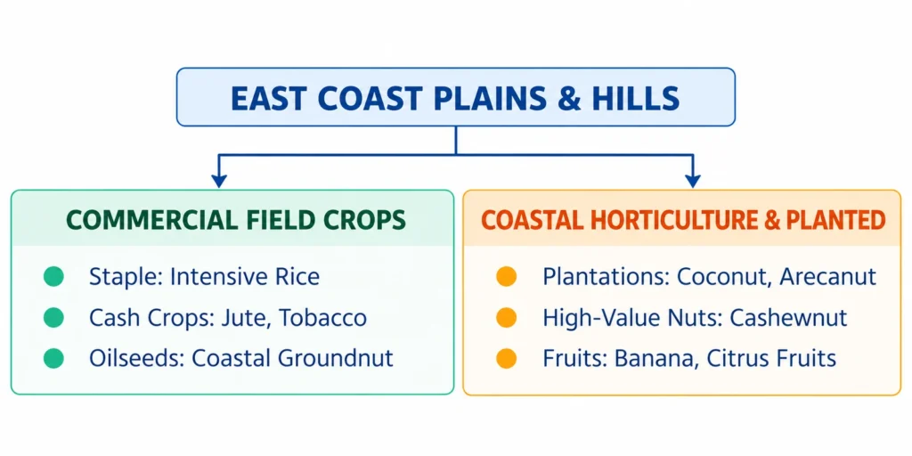
- Dominant Agronomic Matrix: Built around intensive Rice-based cropping sequences. Key commercial cash crops include Jute (in northern delta zones), Flue-Cured Virginia (FCV) Tobacco (predominantly in the riverine/coastal plains of Andhra Pradesh), Sugarcane, Maize, and Millets.
- Coastal Horticulture Matrix: The coastal micro-climate enables extensive commercial cultivation of high-value plantation matrices:
- Plantation Crops: Coconut and Arecanut line the coastal dunes and homestead farms.
- Horticultural Value Chains: Premium Cashewnut, Banana, and assorted Citrus fruits are produced abundantly.
4. Core Problems & Strategic Solutions
Structural & Biophysical Problems
- Edaphic Salinity and Alkalinity: Excessive groundwater pumping combined with storm surges causes widespread soil alkalinity and coastal salinity, impairing crop root physiology.
- Monoculture Vulnerability: Over-reliance on intensive Rice monoculture depletes soil health, lowers the local water table, and increases susceptibility to devastating pest outbreaks (e.g., Brown Plant Hopper).
- Cyclonic Disruptions: Frequent late-monsoon tropical cyclones and seawater inundation cause severe post-harvest damage to standing crops.
Strategic Solutions
- De-escalation of Rice Monoculture: Discourage perpetual rice-rice rotations by enforcing crop diversification models, especially introducing low-water-requiring legumes and pulses in rice fallows.
- Vertical Scaling of Cropping Intensity: Maximize the utilization of land resources by designing multi-tier cropping models combining tall canopy trees (Coconut) with shade-tolerant ground crops (Spices/Tubers).
- Commercial Spice and High-Value Crop Expansion: Accelerate the acreage of lucrative coastal spices (such as Turmeric and Ginger) and salt-tolerant floriculture to boost smallholder income.
Zone 12: The West Coast Plains and Ghats Region – UPSC Agriculture Optional
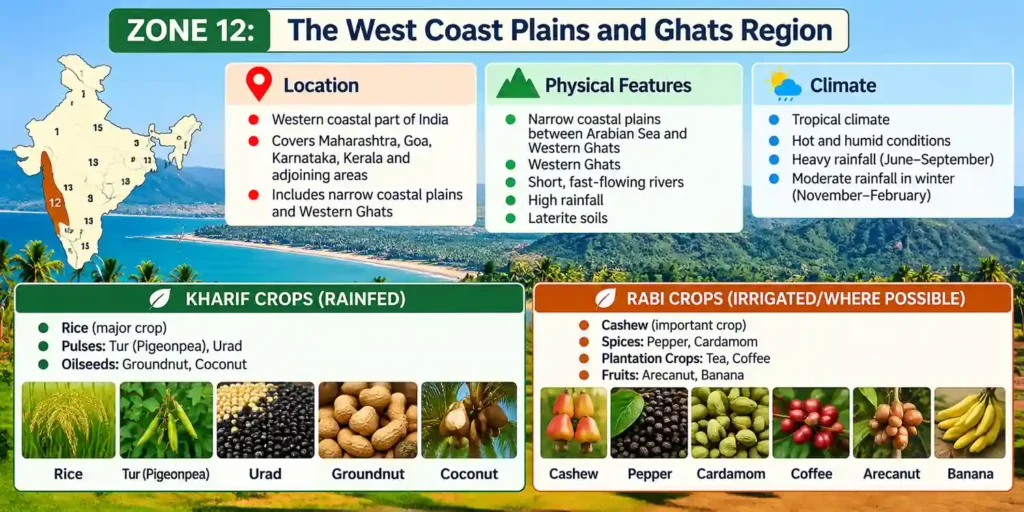
The West Coast Plains and Ghats Region is a per-humid, highly biodiverse ecological corridor stretching along the western peninsular rim of India. In the UPSC Agriculture Optional syllabus, it represents the premier zone for studying multi-tier plantation systems, acid soil management, and high-value integrated marine-brackish water farming.
1. Biophysical and Ecological Profile
- Geographic Spread: Encompasses the narrow coastal strip of western India and the flanking mountain ranges, specifically including the Malabar Coast, the Konkan Coastal Plains, and the Sahyadris (Western Ghats) across Kerala, Karnataka, Goa, and Maharashtra.
- Climate & Rainfall: Characterized by a per-humid to humid tropical climate with well-moderated maritime temperatures. Mean temperatures range from 25°C to 30°C in July and 18°C to 30°C in January. It experiences heavy, prolonged precipitation, with the mean annual rainfall consistently exceeding 200 cm, driven by the structural interception of the South-West monsoon.
- Edaphic Matrix (Soils): Composed of two distinct soil profiles:
- Laterite Soils: Prevail along the high-elevation hill slopes and mid-lands; intensely leached, highly acidic, and rich in Iron and Aluminum oxides but deficient in available Phosphorus and Calcium.
- Coastal Alluvium: Found along the narrow coastal plain; medium-to-coarse textured, deep, and moderately fertile, but prone to localized seawater intrusion.
2. Cropping Patterns and Farming Systems
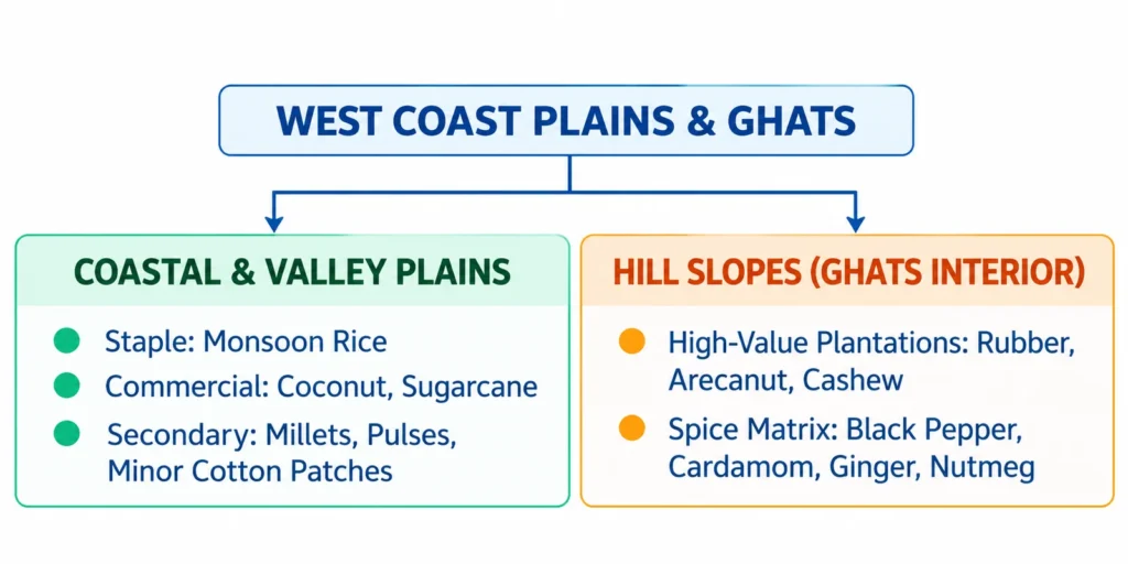
- Coastal and Lowland Plains: Rice is the primary food crop grown during the rainy season. Coconut plantations form a ubiquitous commercial canopy layer along the coast, interspersed with sugarcane, pulses, and minor millets.
- High-Value Mountain Plantations: The hill slopes of the Western Ghats are utilized for high-revenue commercial plantations, featuring Natural Rubber, Arecanut, and Cashew.
- The Spice Matrix: This zone is India’s historic spice bowl, producing premium Black Pepper, Cardamom, Ginger, Clove, and Nutmeg under canopy-shaded micro-climates.
- Allied Marine Sector: Fisheries (both marine capture and inland/brackish aquaculture) constitute an essential economic driver, deeply integrated into the rural coastal farming system.
3. Core Problems & Strategic Solutions
Structural & Biophysical Problems
- Severe Edaphic Acidity and Nutrient Fixation: Heavy precipitation leaches out exchangeable bases from laterite soils, fixing applied Phosphorus as insoluble iron/aluminum compounds.
- Coastal Salinity and Backwater Inundation: Low-lying rice fields face seasonal intrusion of brackish water from expanding networks of backwaters and lagoons.
- Topographic Soil Erosion: Steep slope clearings for plantation expansions accelerate rill and sheet erosion, destroying the thin forest topsoil.
Strategic Solutions
- Promotion of High-Value Matrices: Incentivize the vertical expansion of multi-tier agroforestry models to maximize per-unit land productivity without clearing natural forest cover.
- Brackish Water Aquaculture Integration: Upgrade vulnerable coastal lowlands by expanding scientific prawn culture and shrimp farming in brackish water zones to maximize non-crop revenues.
- Edaphic Neutralization: Institutionalize regular liming programs using agricultural lime or dolomite to correct soil acidity and enhance fertilizer use efficiency (FUE).
Zone 13: The Gujarat Plains and Hills Region – UPSC Agriculture Optional
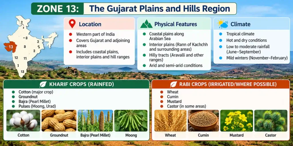
The Gujarat Plains and Hills Region is a major commercial, oilseed-centric zone characterized by wide climate variations from arid to semi-arid, a diverse soil landscape, and a high reliance on groundwater. In the UPSC Agriculture Optional syllabus, it represents a core region for studying cotton-groundnut crop complexes, dryland water management, and the reclamation of saline coastal wastelands.
1. Biophysical and Ecological Profile
- Geographic Spread: Encompasses the arid and semi-arid hills and plains of the Kathiawar (Saurashtra) Peninsula, the rugged terrain of Kutch, and the fertile, alluvial valleys of the Mahi and Sabarmati rivers in central/mainland Gujarat.
- Climate & Rainfall: Characterized as predominantly arid to semi-arid. Summer temperatures are high, with a mean July reading of around 30°C, while winters are warm and mild, with a mean January temperature of about 25°C. The mean annual rainfall is low and highly erratic, varying between 50 cm and 100 cm (decreasing sharply toward the north and west).
- Edaphic Matrix (Soils): Highly diverse and distributed across distinct physiographic zones:
- Regur Soils (Black Cotton Soils): Dominate the Saurashtra plateau region; clayey, highly retentive of moisture, and ideal for deep-rooted crops.
- Alluvial Soils: Formed along the fertile central plains and coastal river basins.
- Red and Yellow Soils: Found in localized pockets, particularly around the Jamnagar area.
2. Water Resources and Irrigation Footprint
- Irrigation Sources: The region exhibits a moderate irrigation profile, with only 22.5% of the net sown area under assured irrigation.
- Infrastructure & Constraints: Agricultural water is primarily extracted via open wells and tube wells. Over-extraction has led to severe groundwater depletion, causing water tables to drop and triggering lateral seawater intrusion along the lengthy coastline.
3. Cropping Patterns and Farming Systems
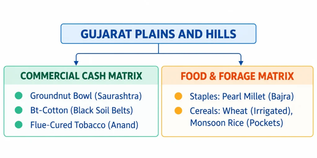
- The Commercial Cash Crop Complex: The region’s economy is highly commercialized and stands out as a critical national engine for oilseed and fiber production:
- Groundnut Bowl: The Saurashtra peninsula is one of India’s premier groundnut-producing zones, thriving in the well-drained red-yellow and lighter black soils.
- Cotton and Tobacco: High-density cultivation of Bt-Cotton occurs across the rich black soil tracts. Central Gujarat (particularly the Anand/Khed district or Charotar tract) is a major hub for commercial Tobacco cultivation.
- Food and Subsistence Cereals: Pearl Millet (Bajra) is the dominant drought-hardy food crop in the hyper-arid patches. Where winter tube-well irrigation is available, Wheat is grown during Rabi, along with secondary monsoon Rice in low-lying, canal-fed valleys.
4. Core Problems & Strategic Solutions
Structural & Biophysical Problems
- Severe Over-Exploitation of Aquifers: Unregulated tube-well pumping for cash crops has caused a alarming decline in groundwater levels.
- Coastal Salinity Ingress: The drawdown of fresh groundwater tables along the coastal fringe has allowed marine water to intrude inland, rendering soils and wells brackish.
- High Drought Vulnerability: Erratic monsoon onset and frequent terminal dry spells make rainfed groundnut farming a highly risky endeavor.
Strategic Solutions
- Decentralized Rainwater Harvesting: Construct check dams, farm ponds, and implement village-level bori-bunds to capture sporadic monsoon runoff and actively recharge shallow unconfined aquifers.
- Integrated Surface and Groundwater Management: Promote conjunctive water use (blending canal water with groundwater) to stabilize water tables and suppress further coastal salinity ingress.
- Dryland Farming Technologies: Mandate the use of water-efficient micro-irrigation systems (drip irrigation for cotton and sprinklers for groundnuts) to maximize crop water-use efficiency (WUE).
- Wasteland and Salt Plain Development: Reclaim degraded soils and seasonal mudflats (like the margins of the Rann of Kutch) by planting salt-tolerant, halophytic silviculture components and high-value arid forage crops.
Zone 14 : The Western Dry Region (Thar Desert)
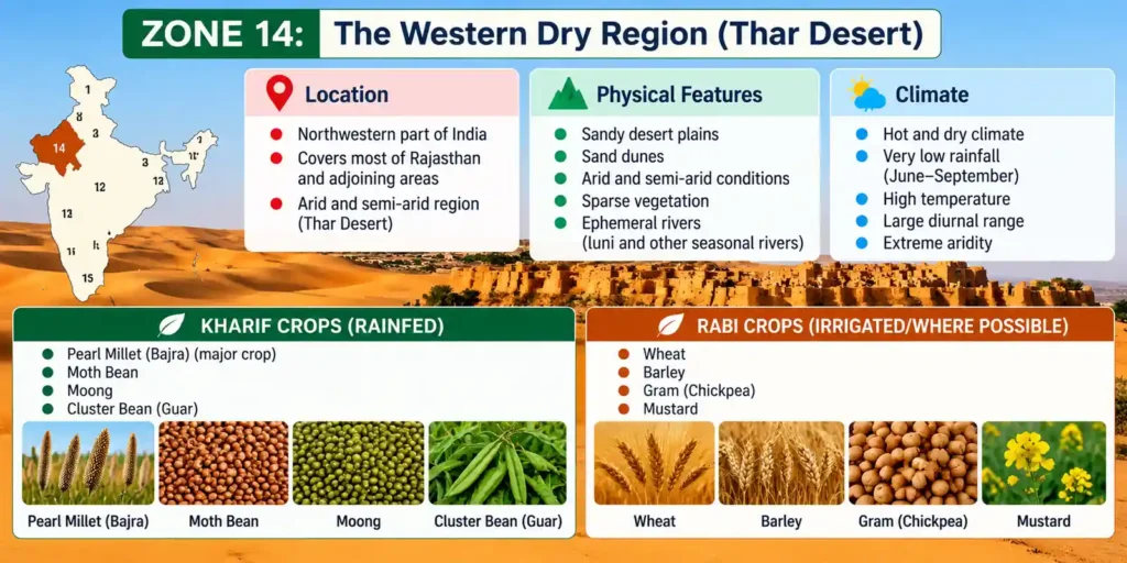
The Western Dry Region constitutes India’s hyper-arid desert core, characterized by an average annual rainfall under 25 cm, sandy desert soils, and an agricultural system heavily dependent on desert livestock ecology. In the UPSC Agriculture Optional syllabus, this zone represents the definitive study area for hyper-arid dryland farming, dune stabilization, and canal-induced ecosystem modifications.
1. Biophysical and Ecological Profile
- Geographic Spread: Encompasses the arid and semi-arid hills and plains of the Kathiawar (Saurashtra) Peninsula, the rugged terrain of Kutch, and the fertile, alluvial valleys of the Mahi and Sabarmati rivers in central/mainland Gujarat.
- Climate & Rainfall: Characterized as predominantly arid to semi-arid. Summer temperatures are high, with a mean July reading of around 30°C, while winters are warm and mild, with a mean January temperature of about 25°C. The mean annual rainfall is low and highly erratic, varying between 50 cm and 100 cm (decreasing sharply toward the north and west).
- Edaphic Matrix (Soils): Highly diverse and distributed across distinct physiographic zones:
- Regur Soils (Black Cotton Soils): Dominate the Saurashtra plateau region; clayey, highly retentive of moisture, and ideal for deep-rooted crops.
- Alluvial Soils: Formed along the fertile central plains and coastal river basins.
- Red and Yellow Soils: Found in localized pockets, particularly around the Jamnagar area.
2. Water Resources and Irrigation Footprint
- Irrigation Sources: The region exhibits a moderate irrigation profile, with only 22.5% of the net sown area under assured irrigation.
- Infrastructure & Constraints: Agricultural water is primarily extracted via open wells and tube wells. Over-extraction has led to severe groundwater depletion, causing water tables to drop and triggering lateral seawater intrusion along the lengthy coastline.
3. Cropping Patterns and Farming Systems
- The Commercial Cash Crop Complex: The region’s economy is highly commercialized and stands out as a critical national engine for oilseed and fiber production:
- Groundnut Bowl: The Saurashtra peninsula is one of India’s premier groundnut-producing zones, thriving in the well-drained red-yellow and lighter black soils.
- Cotton and Tobacco: High-density cultivation of Bt-Cotton occurs across the rich black soil tracts. Central Gujarat (particularly the Anand/Kheda district or Charotar tract) is a major hub for commercial Tobacco cultivation.
- Food and Subsistence Cereals: Pearl Millet (Bajra) is the dominant drought-hardy food crop in the hyper-arid patches. Where winter tube-well irrigation is available, Wheat is grown during Rabi, along with secondary monsoon Rice in low-lying, canal-fed valleys.
4. Core Problems & Strategic Solutions
Structural & Biophysical Problems
- Severe Over-Exploitation of Aquifers: Unregulated tube-well pumping for cash crops has caused a alarming decline in groundwater levels.
- Coastal Salinity Ingress: The drawdown of fresh groundwater tables along the coastal fringe has allowed marine water to intrude inland, rendering soils and wells brackish.
- High Drought Vulnerability: Erratic monsoon onset and frequent terminal dry spells make rainfed groundnut farming a highly risky endeavor.
Strategic Solutions
- Decentralized Rainwater Harvesting: Construct check dams, farm ponds, and implement village-level bori-bunds to capture sporadic monsoon runoff and actively recharge shallow unconfined aquifers.
- Integrated Surface and Groundwater Management: Promote conjunctive water use (blending canal water with groundwater) to stabilize water tables and suppress further coastal salinity ingress.
- Dryland Farming Technologies: Mandate the use of water-efficient micro-irrigation systems (drip irrigation for cotton and sprinklers for groundnuts) to maximize crop water-use efficiency (WUE).
- Wasteland and Salt Plain Development: Reclaim degraded soils and seasonal mudflats (like the margins of the Rann of Kutch) by planting salt-tolerant, halophytic silviculture components and high-value arid forage crops.
Zone 15: The Islands Region
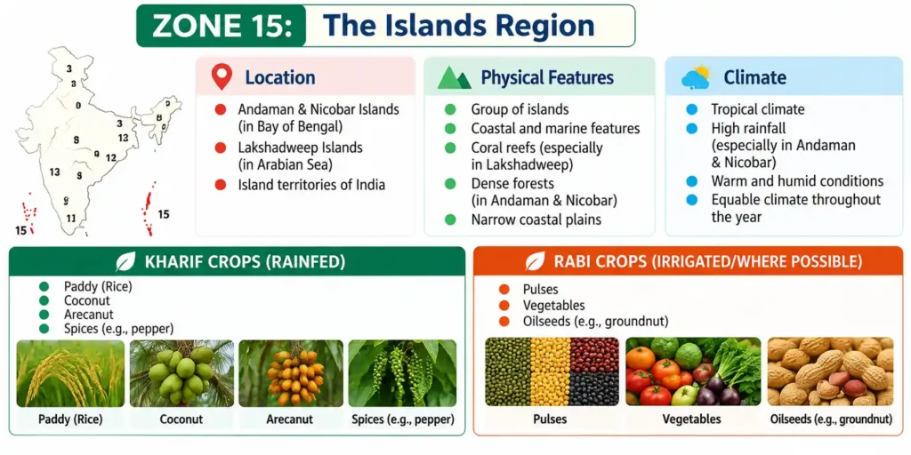
The Islands Region constitutes India’s outermost maritime territories, characterized by a humid equatorial climate, highly distinct island pedology, and an agricultural matrix dominated by coconut plantations and coastal ecosystems. In the UPSC Agriculture Optional syllabus, this final zone serves as the definitive model for studying maritime agroforestry, blue economy integration, and multi-tier plantation systems.
1. Biophysical and Ecological Profile
- Geographic Spread: Encompasses the dual island territories of India: the Andaman & Nicobar Islands in the Bay of Bengal and the Lakshadweep Islands in the Arabian Sea.
- Climate & Rainfall: Characterized by a humid equatorial maritime climate with minimal seasonal thermal variations. Ambient temperatures remain warm and consistent, ranging between 23°C and 31°C. The region experiences high annual rainfall spanning 160 cm to 300 cm, distributed across a prolonged rainy season driven by both the South-West and North-East monsoons.
- Edaphic Matrix (Soils): Highly divergent between the two island groups:
- Lakshadweep Group: Soils are highly calcareous, coral-derived, and sandy. They feature extremely high pH, high porous infiltration rates, and severe deficiencies in essential micronutrients like Iron (Fe) and Zinc (Zn).
- Andaman & Nicobar Group: Soils range from medium to very deep red loamy soils in the interiors to fertile marine alluvium-derived soils along the narrow coastal fringes.
2. Cropping Patterns and Farming Systems
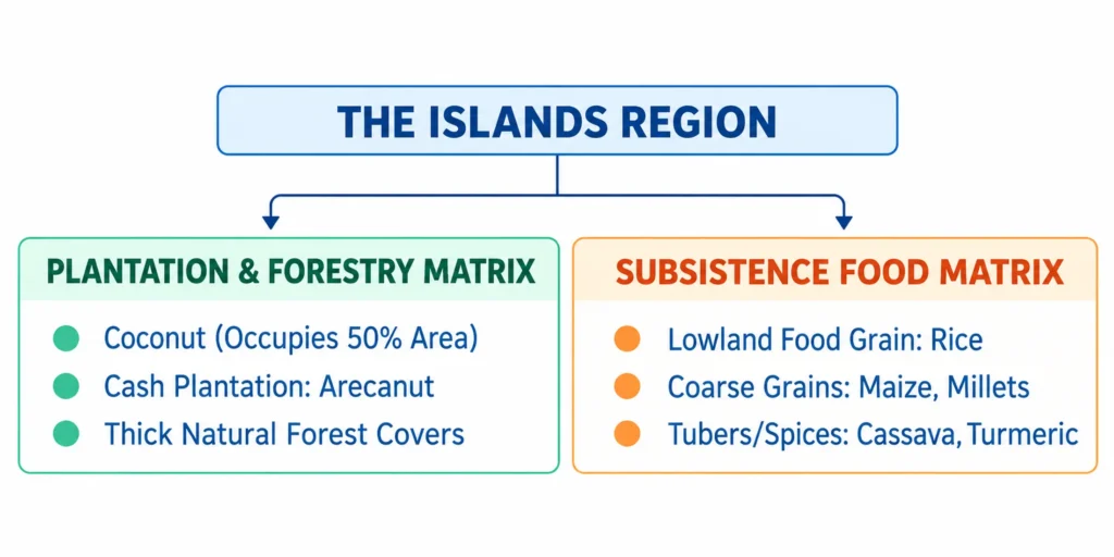
- The Coconut Economy: Coconut is the undisputed anchor of regional agriculture, occupying nearly half (50%) of the total cultivated land area.
- Agronomic Profile: Other prominent crops include Arecanut, Turmeric, and Cassava (Tapioca). Lowland Rice serves as the primary seasonal food grain, supplemented by minor patches of Maize, Millets, and Pulses.
- Ecological Status: A massive proportion of the geographical area remains under protected, thick tropical rainforest covers. Consequently, field agriculture remains in a relatively backward, subsistence-oriented stage due to physical isolation and land availability constraints.
3. Core Problems & Strategic Solutions
Structural & Biophysical Problems
- Logistical Isolation: High geographic distance from mainland markets drives up the input cost of fertilizers, seeds, and machinery while impeding fresh crop exports.
- Calcareous Imbalances in Coral Soils: The coral-sandy soils of Lakshadweep suffer from severe nutrient locks, leading to widespread chlorosis and poor crop yields outside coconut palm networks.
- Fragile Island Eco-efficiency: Thin topsoil profiles on sloped forest land are highly prone to irreversible degradation if cleared for intensive field agriculture.
Strategic Solutions
- Exploitation of Silviculture Frameworks: Leverage the thick forest biome by introducing sustainable, high-value silviculture and agroforestry models (such as cultivating vanilla or black pepper vines on forest tree canopies) to generate income without causing deforestation.
- Aquaculture and Blue Economy Scaling: Given the vast Exclusive Economic Zone (EEZ), aggressively scale up brackish water aquaculture, seaweed farming, and cage culture for high-value marine species to diversify economic returns.
- Organic Plantation Hubs: Transform the entire region into a dedicated chemical-free zone focusing on high-value organic coconut oil, coir processing, and premium processed spices for global export markets.
Previous Year Question based on it
- Discuss about the cropping patterns of Middle Gangetic Plain and Western Plateau and hills. (20M, CSE 2024)
- Discuss the geographic factors used by the National Bureau of Soil Survey and Land Use Planning (NBSS & LUP) for agroecological zoning in India. (10M, IFoS-2023)
- Describe the basis of classification of agro-ecological zones of India. Give the important characteristics and cropping patterns of any two zones. (10M, IFoS-2019)
- Enlist the agro climatic zones of India and give their important cropping patterns. (8M, 150W, IFoS-2018)
- What are the climatic parameters affecting crop productivity according to which farmers follow the cropping pattern in the western zone of the country? (8M, 150W, IFoS-2017)
- Describe the basis of classification of agro-ecological zones of India.
- Give the important characteristics of any two zones with their states/regions and major cropping patterns. (8M, 150W, IFoS-2016)
- Describe the agricultural regions of India. (10M, 150W, CSE 2015)
- How are the agro-climatic zones determined? (10M, 150W, CSE 2015)
- Microclimate. (200W, CSE 1990)